GUIDE - instructor's station
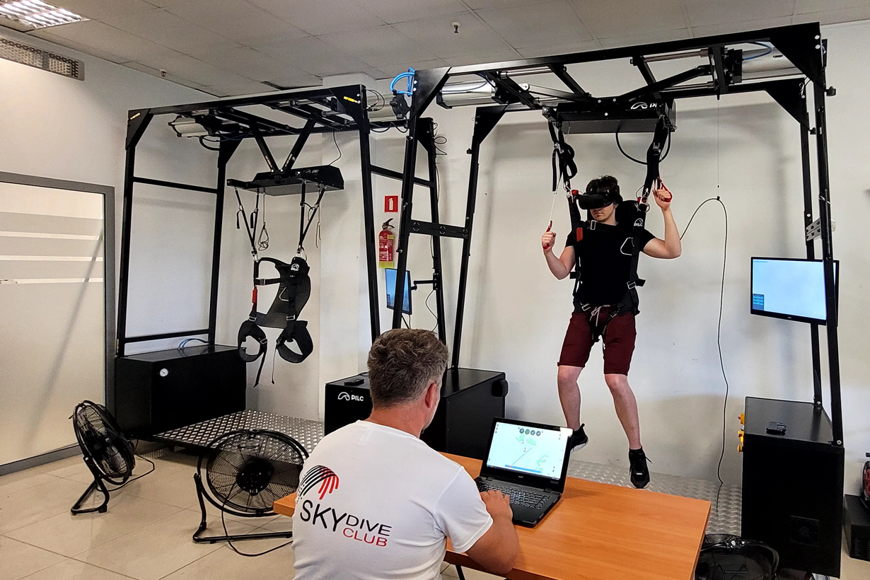
Every moment of training must be used effectively. In training, there is no time to make mistakes that will not be knowledgeable. So far, the main co-ordinator of training has been the season and the weather. They dictated whether the training would take place. Obviously, in winter, parachuting was performed very little, and the length of the day determined the possibility of undergoing practical training. With the designed GUIDE training environment, the PSVR-04 simulator, the GUARDA data acquisition system, and the GURU transmission module, you can increase the training efficiency! Is the weather fine? Is it already dark? Now, for theoretical and practical training on the ground, it is of lesser importance, because you can practice effectively in VR simulation. And when the season starts, you can start practical training and verify the progress of training on a regular basis.
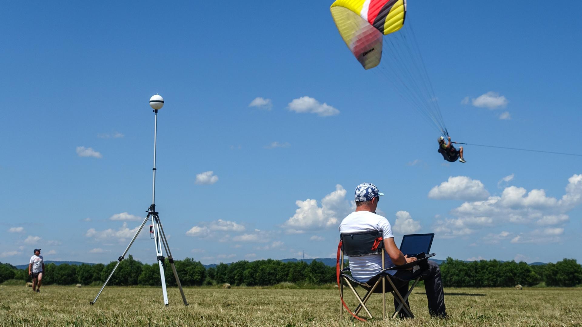
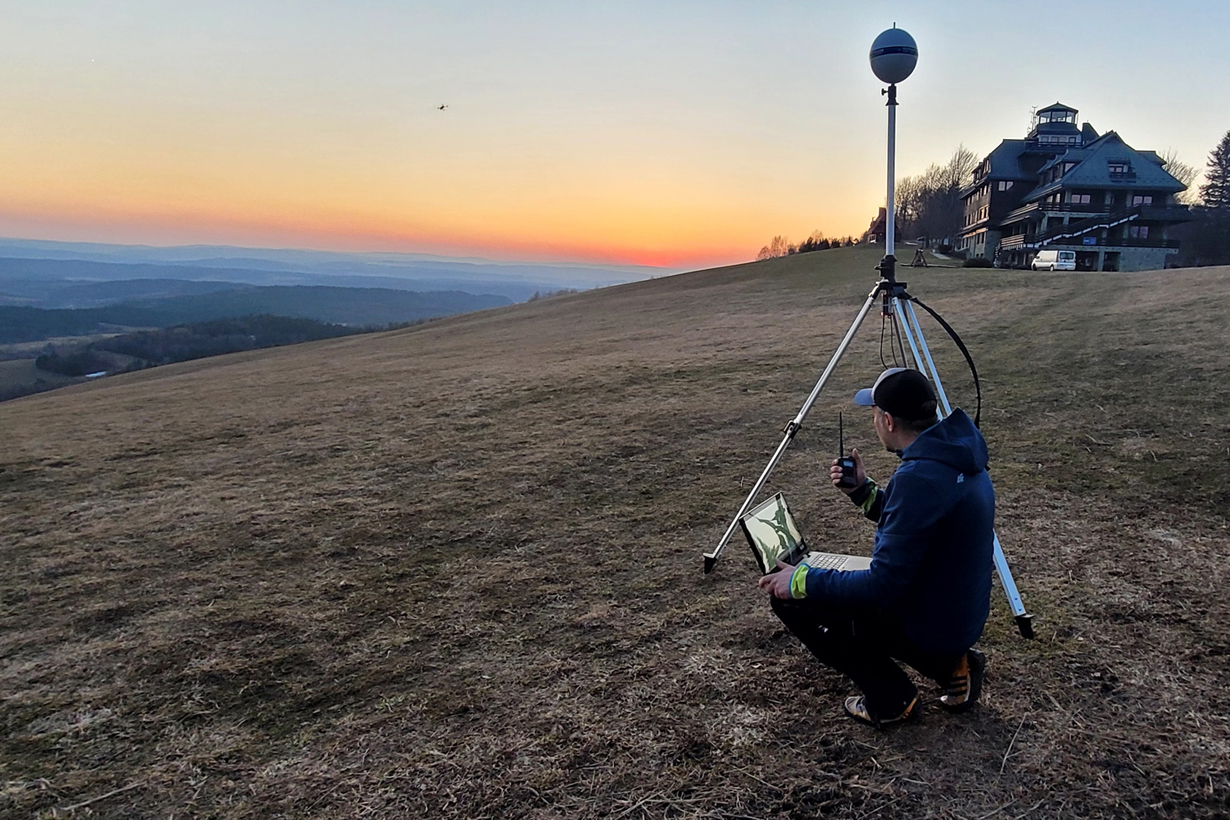
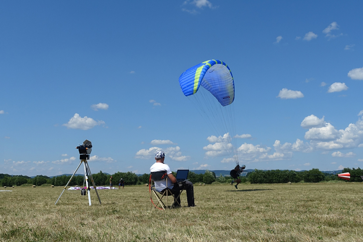
We are pleased to present the GUIDE instructor’s station, which has been designed to improve the effectiveness of training. It allows for ongoing supervision and control over the PSVR-04 simulators, but also through the GURU transmission system for ongoing supervision over the real flights.
GUIDE - stanowisko instruktora
Every moment of training must be used effectively. In training, there is no time to make mistakes that will not be knowledgeable. So far, the main co-ordinator of training has been the season and the weather. They dictated whether the training would take place. Obviously, in winter, parachuting was performed very little, and the length of the day determined the possibility of undergoing practical training. With the designed GUIDE training environment, the PSVR-04 simulator, the GUARDA data acquisition system, and the GURU transmission module, you can increase the training efficiency! Is the weather fine? Is it already dark? Now, for theoretical and practical training on the ground, it is of lesser importance, because you can practice effectively in VR simulation. And when the season starts, you can start practical training and verify the progress of training on a regular basis.
We are pleased to present the GUIDE instructor’s station, which has been designed to improve the effectiveness of training. It allows for ongoing supervision and control over the PSVR-04 simulators, but also through the GURU transmission system for ongoing supervision over the real flights.

Let us GUIDE you
- Don't waste your time
- Read recorded flight data
- One environment for ground and air training
- Manage the mission during group jumps
- Increase the effectiveness of simulation training
- Increase the safety of the flight training
- Detect dangers faster
- The element of the PSSP-01 system
- Development opportunities
In simulation training, what matters is how much you fly, not how much you will wait for the flight. Each change of the jump parameters in the simulation takes time. For this reason, we have designed our system to waste as little time as possible. To achieve this, the GUIDE software has:
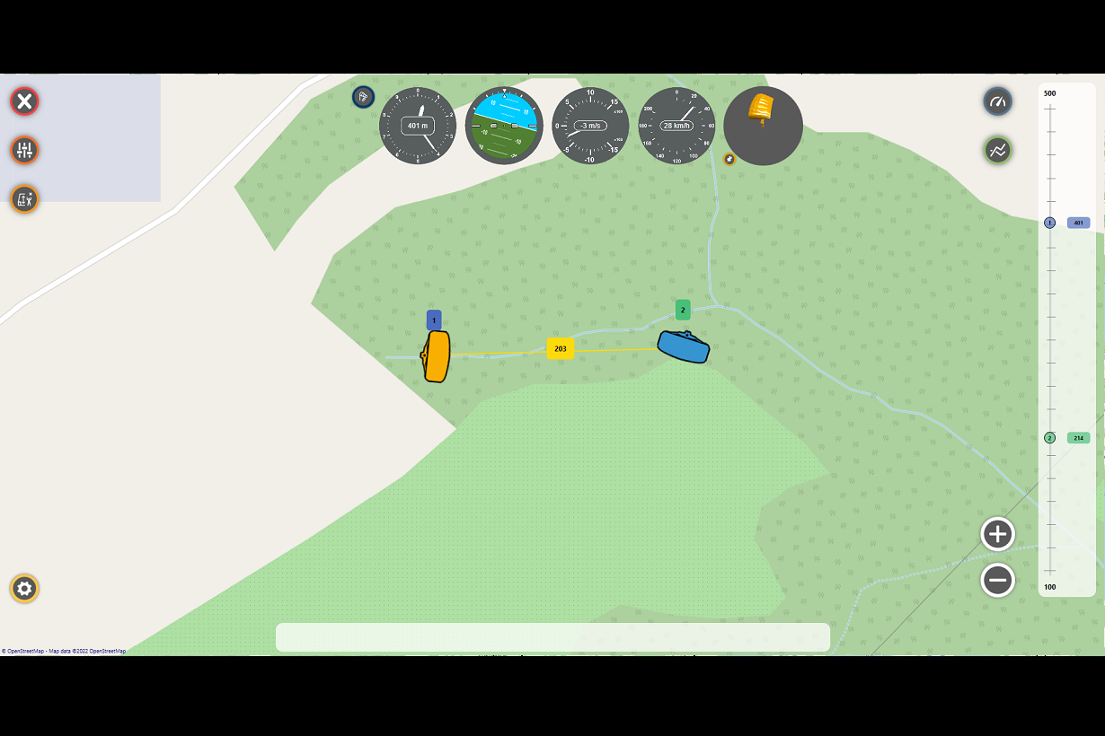
The instructor's station is not only about current supervision of flight. We have equipped it with the same functions that allow you to read data from the GUARDA data logger. Thanks to this, you no longer have to analyze the data collected during the flight with separate software! Everything has been combined so that the flight analysis on an ongoing basis and post-flight briefing are even more effective.
We know very well that the equipment costs money. If it is to be effective in training, it must be used. Bearing in mind that the training is carried out to a large extent by small centers, we decided that the training station designed by us could be used both during the ground training phase and in the flight training phase. The gap between theoretical knowledge acquired on the ground and skills acquired in the air has been reduced! Instructors can consciously and effectively support students in assignments where it was previously impossible.
Group jumping and learning formation flights are one of the most difficult tasks related to air navigation. Thanks to the GUIDE instructor environment, you can easily synchronize the work of up to 10 simulators, set the same weather conditions, and load a dedicated mission plan to be carried out anywhere on earth. Once you have practiced the missions in the simulator, thanks to the transmission system you will be able to use the same knowledge while supervising the formation in real jumps.
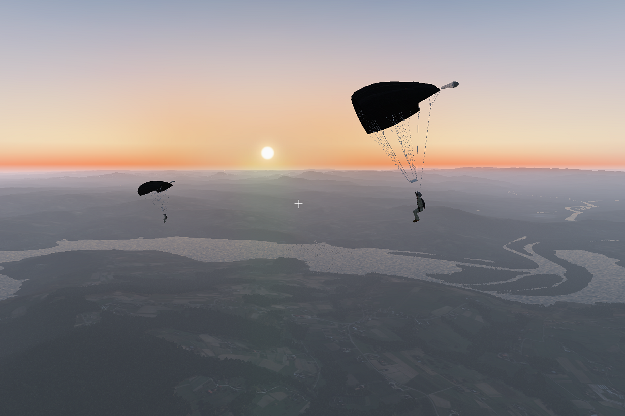
In the simulator, a jump is always safe for life, so their use has a clear purpose ... In safe conditions, practice dangerous situations that may happen in reality, but also learn how to fly safely. Our research has shown that even simple tasks for experienced jumpers, such as planning a round or developing a sense of height, can be a problem for those who are just starting their training. For this reason, we have developed a virtual "beacon” function that will allow you to define the turning points for the student, train in estimation of altitude with the visual method, and also assist with the round planning exercises.
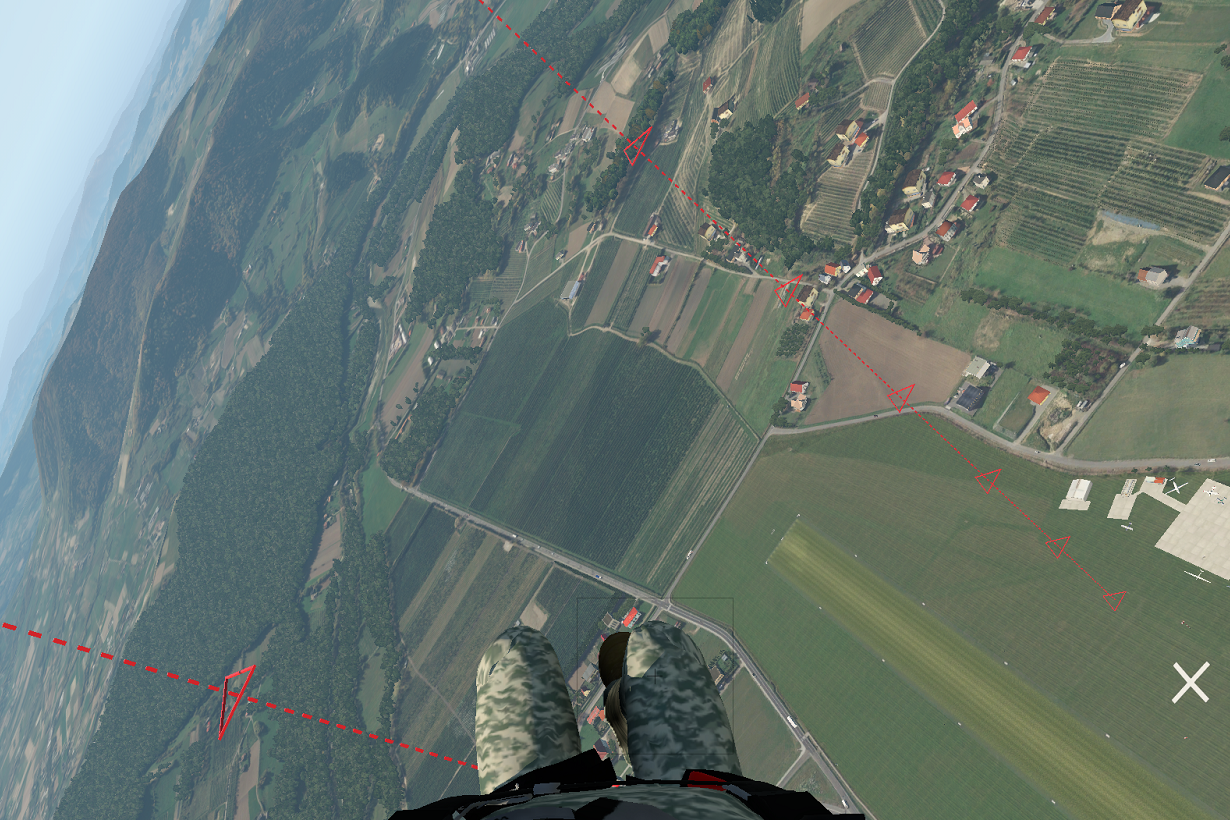
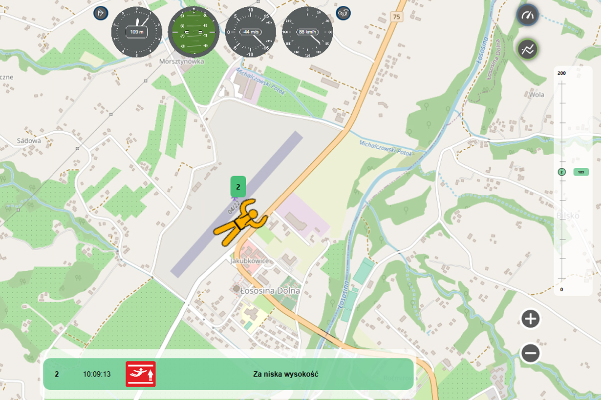
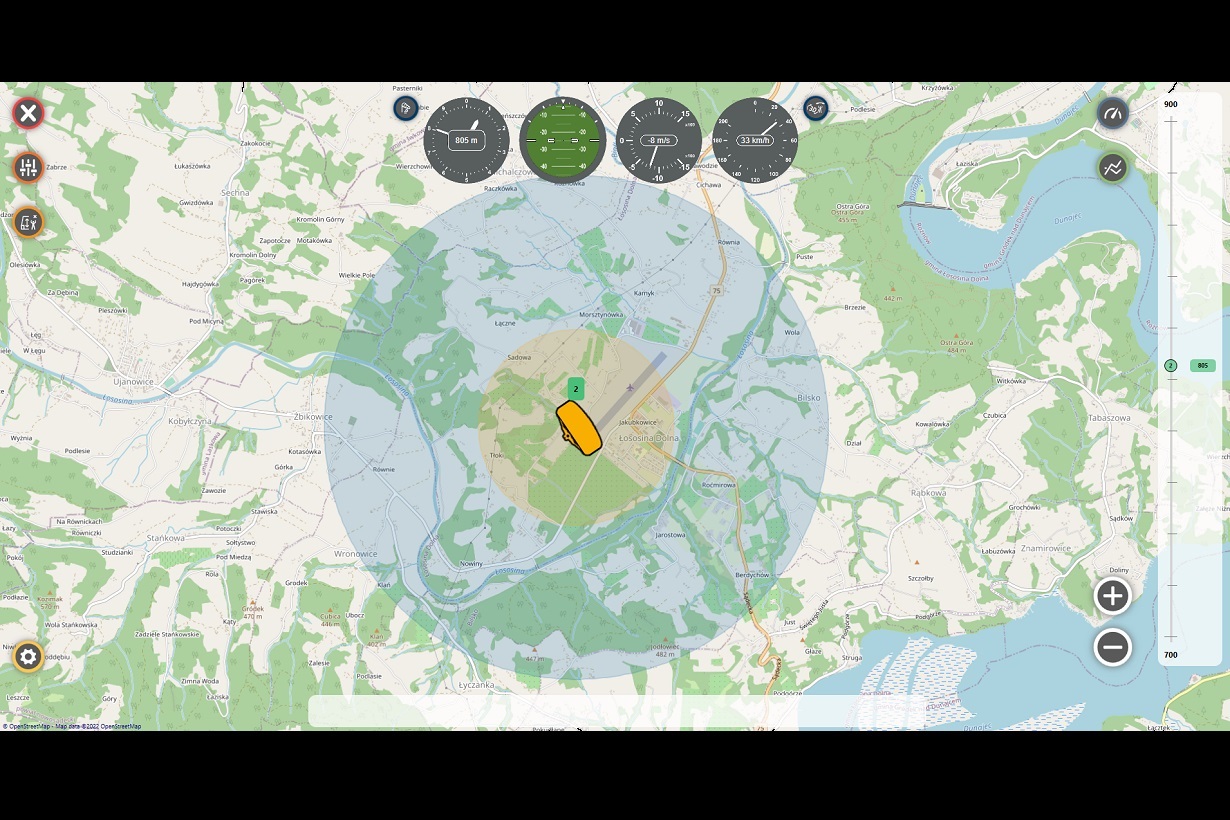
The current supervision of the jumpers is difficult, and sometimes even impossible. After all, it is difficult to see someone in the sky who may be several kilometers away from us. The more difficult it is just based on what you see, where exactly is the trainee in the air and whether he will fly to the airport or not. Incorrect landing site selection in rough terrain has been the cause of many accidents. We wondered how we could help the instructor in this situation so that he could better support the student in taking safe actions. With this in mind, we have developed the Estimated Cone of Range Display function. Thanks to it, you will know if the planned landing point is reachable from the current altitude, and if not, you will help the student in advance in choosing a potential landing place thanks to the built-in map. That's not all ... You will also shorten the time it takes to pick up a person who has landed on rough terrain.
Detecting an unsafe condition is the first necessary step in providing proper assistance. Having additional tools can be effective, but they must allow the instructor to react more quickly to dangers while not involving him too much in the data analysis process. One of the criteria for our system was whether we can detect irregularities faster and react to them. For this reason, we have designed a dedicated warning system for critical situations in the air. Thanks to the experience of the instructors involved in our work, we have formulated functions that allow, inter alia, for automatic detection of:
Our instructor station cooperates with other elements of the PSSP-01 system. You can manage the flight in Virtual Reality Simulators, analyze the flight registered with the GUARDA recorder, and analyze the course of flights on an ongoing basis using GUARDA-TE recorders and the transmission module.
We are aware that everyone has different needs, which is why we will compose a set of system elements appropriate for your center.
You think the system is great, but why do we only dedicate it to paratroopers and paragliders? Nothing could be more wrong. We used it for ongoing supervision over other flying objects, including supervising the course of selected pilots during the Polish MotoParagliding Championships in 2021, and we are currently working with the Supercluster team on the supervision of the stratospheric balloon missions with data logged and supervised from 31km above the ground. Do you think about alternative applications? Contact us and we will try to help you. We offer individual orders regarding:
- designing dedicated software and user interface,
- adapting the system to the needs of training centers,
- designing dedicated scenarios in line with the training program.
Let us GUIDE you
- Don't waste your time
- Read recorded flight data
- One environment for ground and air training
- Manage the mission during group jumps
- Increase the effectiveness of simulation training
- Increase the safety of the flight training
- Detect dangers faster
- The element of the PSSP-01 system
- Możliwości rozwoju
In simulation training, what matters is how much you fly, not how much you will wait for the flight. Each change of the jump parameters in the simulation takes time. For this reason, we have designed our system to waste as little time as possible. To achieve this, the GUIDE software has:
The instructor's station is not only about current supervision of flight. We have equipped it with the same functions that allow you to read data from the GUARDA data logger. Thanks to this, you no longer have to analyze the data collected during the flight with separate software! Everything has been combined so that the flight analysis on an ongoing basis and post-flight briefing are even more effective.
We know very well that the equipment costs money. If it is to be effective in training, it must be used. Bearing in mind that the training is carried out to a large extent by small centers, we decided that the training station designed by us could be used both during the ground training phase and in the flight training phase. The gap between theoretical knowledge acquired on the ground and skills acquired in the air has been reduced! Instructors can consciously and effectively support students in assignments where it was previously impossible.
Group jumping and learning formation flights are one of the most difficult tasks related to air navigation. Thanks to the GUIDE instructor environment, you can easily synchronize the work of up to 10 simulators, set the same weather conditions, and load a dedicated mission plan to be carried out anywhere on earth. Once you have practiced the missions in the simulator, thanks to the transmission system you will be able to use the same knowledge while supervising the formation in real jumps.
In the simulator, a jump is always safe for life, so their use has a clear purpose ... In safe conditions, practice dangerous situations that may happen in reality, but also learn how to fly safely. Our research has shown that even simple tasks for experienced jumpers, such as planning a round or developing a sense of height, can be a problem for those who are just starting their training. For this reason, we have developed a virtual "beacon” function that will allow you to define the turning points for the student, train in estimation of altitude with the visual method, and also assist with the round planning exercises.
The current supervision of the jumpers is difficult, and sometimes even impossible. After all, it is difficult to see someone in the sky who may be several kilometers away from us. The more difficult it is just based on what you see, where exactly is the trainee in the air and whether he will fly to the airport or not. Incorrect landing site selection in rough terrain has been the cause of many accidents. We wondered how we could help the instructor in this situation so that he could better support the student in taking safe actions. With this in mind, we have developed the Estimated Cone of Range Display function. Thanks to it, you will know if the planned landing point is reachable from the current altitude, and if not, you will help the student in advance in choosing a potential landing place thanks to the built-in map. That's not all ... You will also shorten the time it takes to pick up a person who has landed on rough terrain.
Detecting an unsafe condition is the first necessary step in providing proper assistance. Having additional tools can be effective, but they must allow the instructor to react more quickly to dangers while not involving him too much in the data analysis process. One of the criteria for our system was whether we can detect irregularities faster and react to them. For this reason, we have designed a dedicated warning system for critical situations in the air. Thanks to the experience of the instructors involved in our work, we have formulated functions that allow, inter alia, for automatic detection of:
Our instructor station cooperates with other elements of the PSSP-01 system. You can manage the flight in Virtual Reality Simulators, analyze the flight registered with the GUARDA recorder, and analyze the course of flights on an ongoing basis using GUARDA-TE recorders and the transmission module.
We are aware that everyone has different needs, which is why we will compose a set of system elements appropriate for your center.
You think the system is great, but why do we only dedicate it to paratroopers and paragliders? Nothing could be more wrong. We used it for ongoing supervision over other flying objects, including supervising the course of selected pilots during the Polish MotoParagliding Championships in 2021, and we are currently working with the Supercluster team on the supervision of the stratospheric balloon missions with data logged and supervised from 31km above the ground. Do you think about alternative applications? Contact us and we will try to help you. We offer individual orders regarding:
- designing dedicated software and user interface,
- adapting the system to the needs of training centers,
- designing dedicated scenarios in line with the training program.
